Publications
2026
International Journals
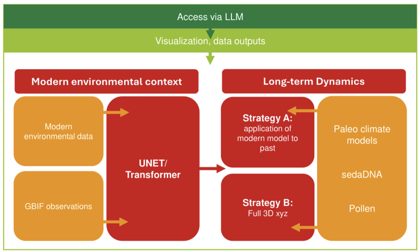
Paleo-grounded biodiversity foundation models for long-horizon species distribution forecasting
Ulrike Herzschuh, et al.
Frontiers in Ecology and Evolution, 2026.
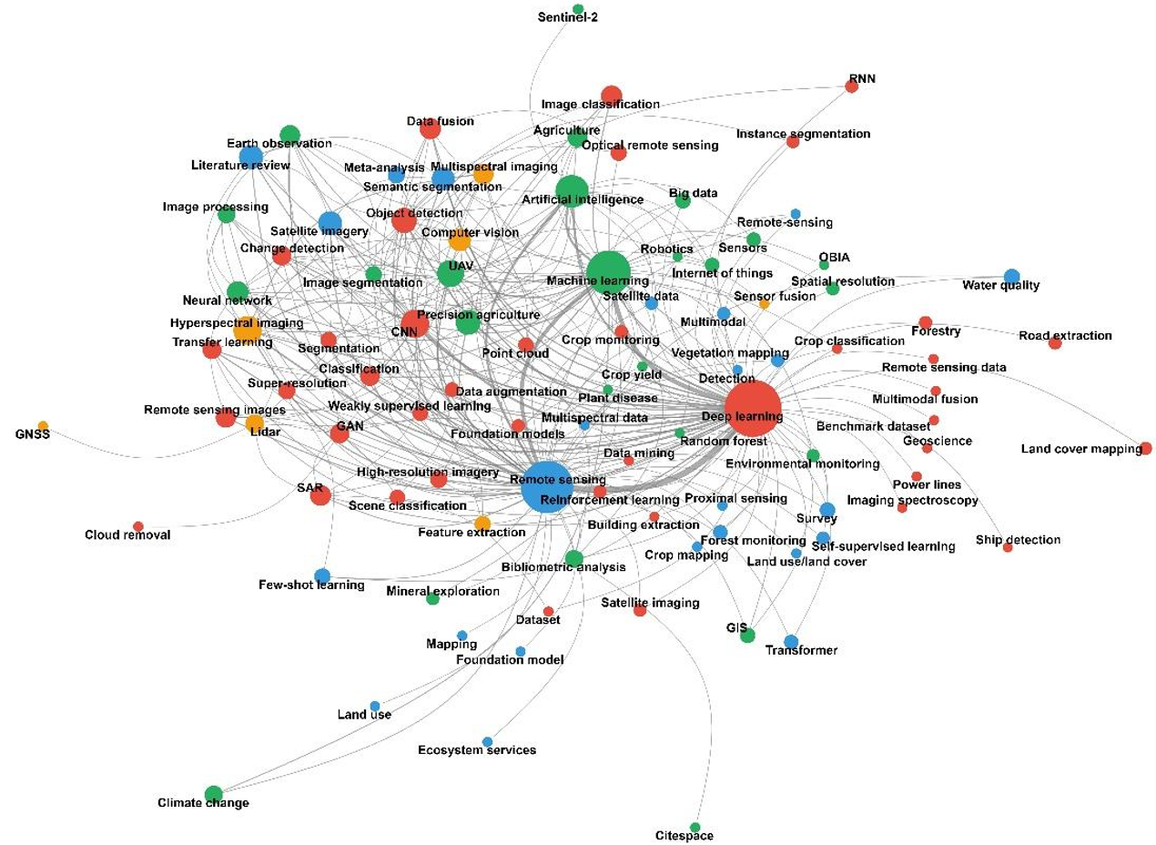
A Decade of Deep Learning in Remote Sensing: A Systematic Review of Reviews
Anastasiia Safonova, Ronny Hänsch, Ribana Rosche, Gilberto Camara, Begüm Demir, Joan Serra-Sagristà and Masahiro Ryo
IEEE Access, 2026.
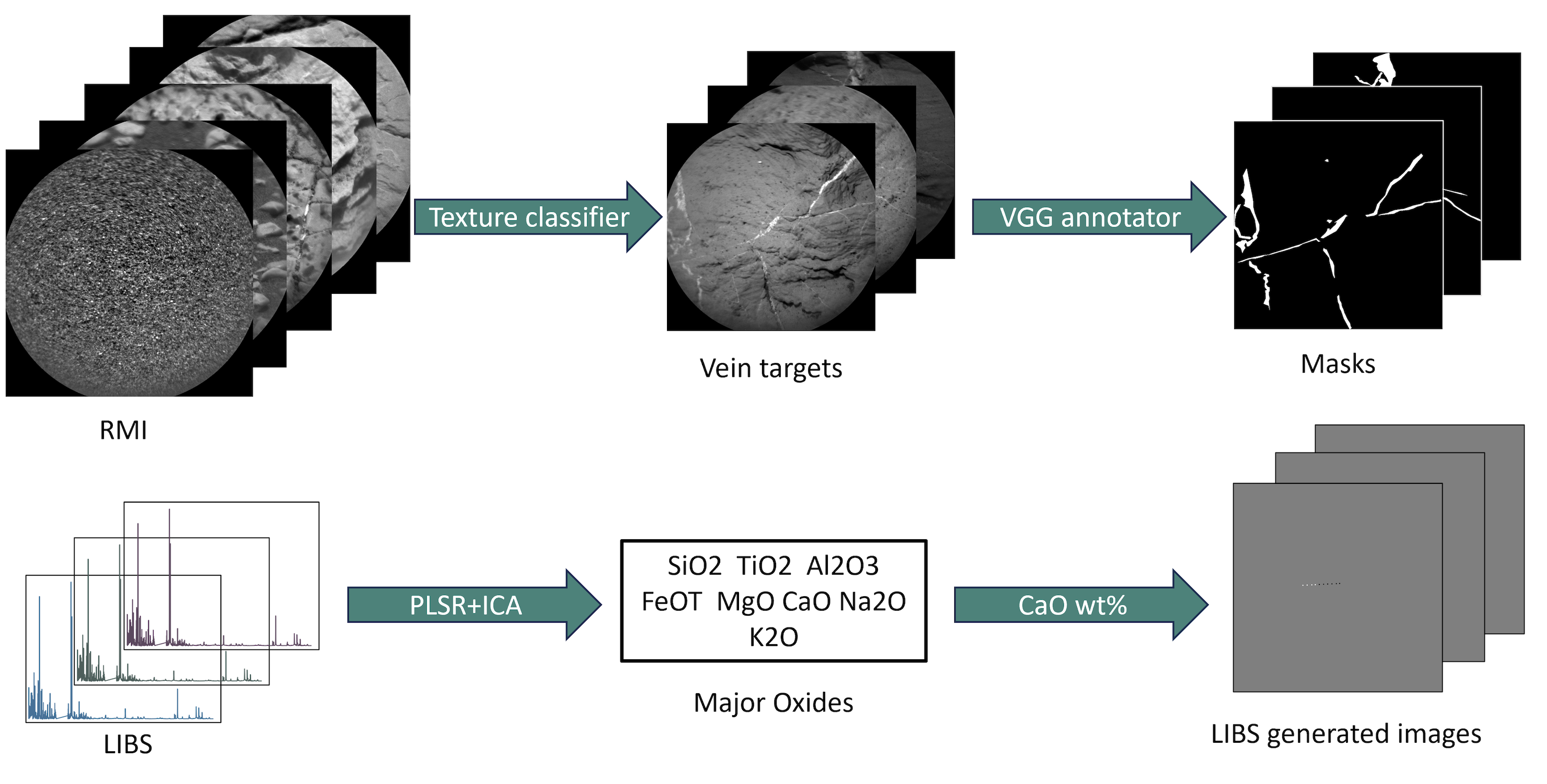
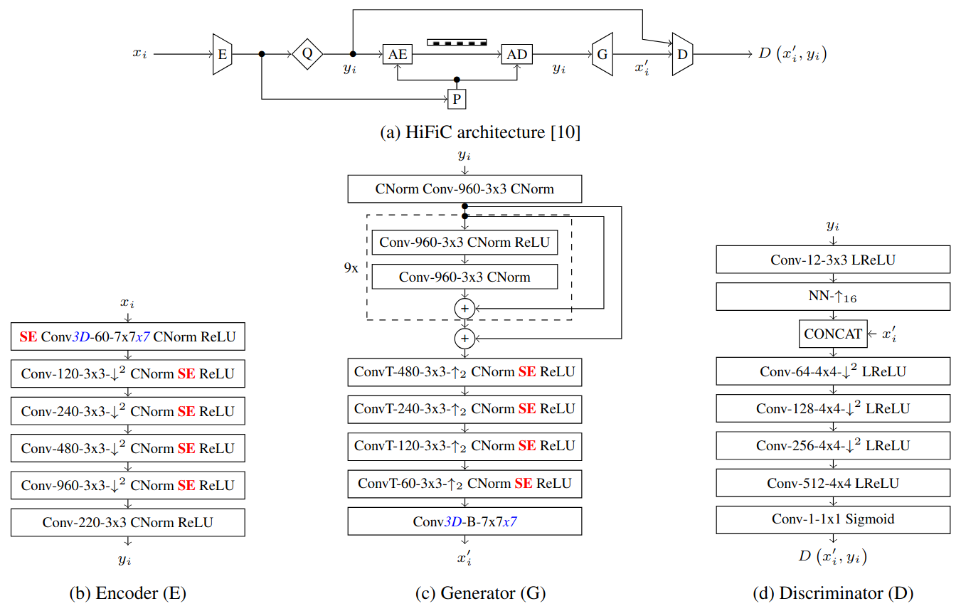
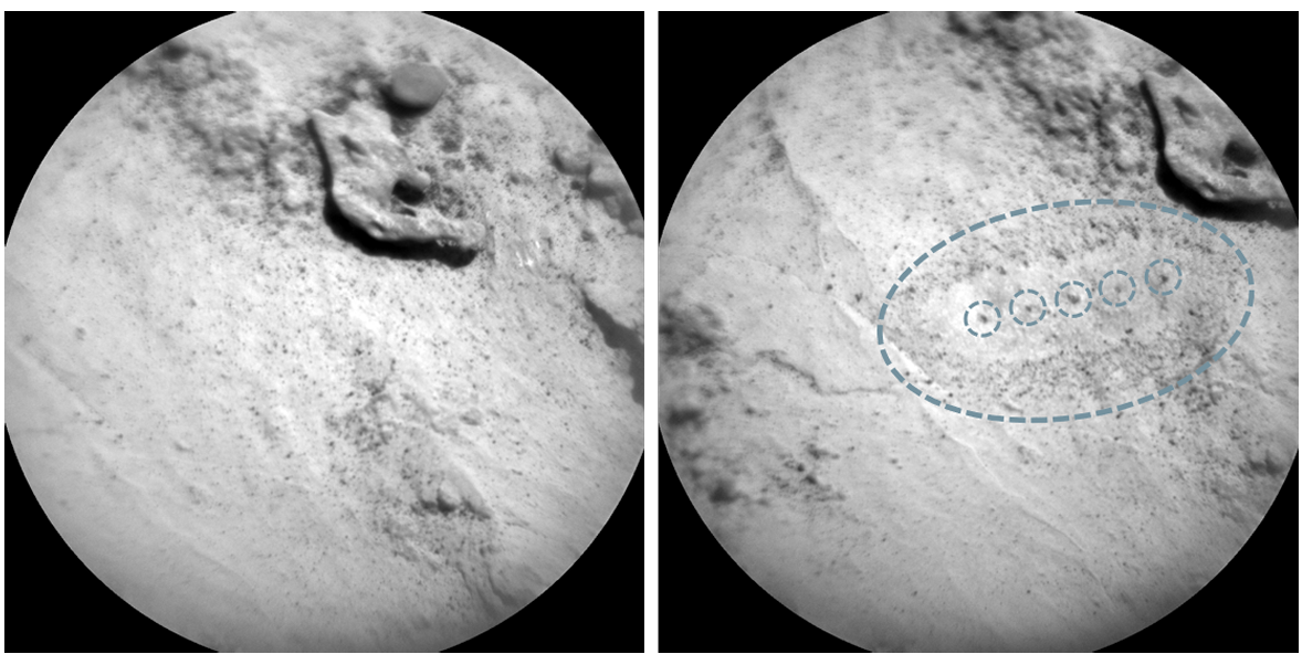
Semantic Segmentation of Light-toned Veins in Multimodal ChemCam Data
Ana Lomashvili, Kristin Rammelkamp, Protim Bhattacharjee, Olivier Gasnault, Elise Clavé, Christoph H. Egerland, Susanne Schröder, Travis S. J. Gabriel, Ari Essunfeld, Stéphane Le Mouélic, Begüm Demir
Springer Nature Scientific Reports, in press, 2026.
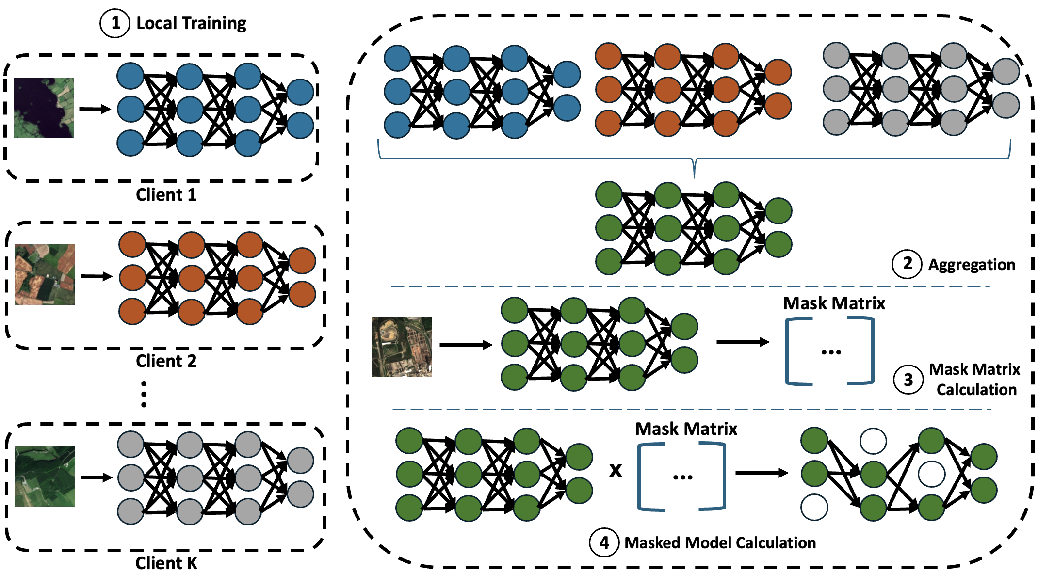
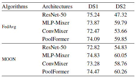
FedX: Explanation-Guided Pruning for Communication-Efficient Federated Learning in Remote Sensing
Barış Büyüktaş*, Jonas Klotz*, Begüm Demir
IEEE Journal of Selected Topics in Applied Earth Observations and Remote Sensing, 2026.
* Equal contribution
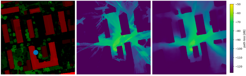
Beam Index Map Prediction in Unseen Environments from Geospatial Data
Fabian Jaensch, Giuseppe Caire, Begüm Demir
IEEE Wireless Communications Letters, 2026.
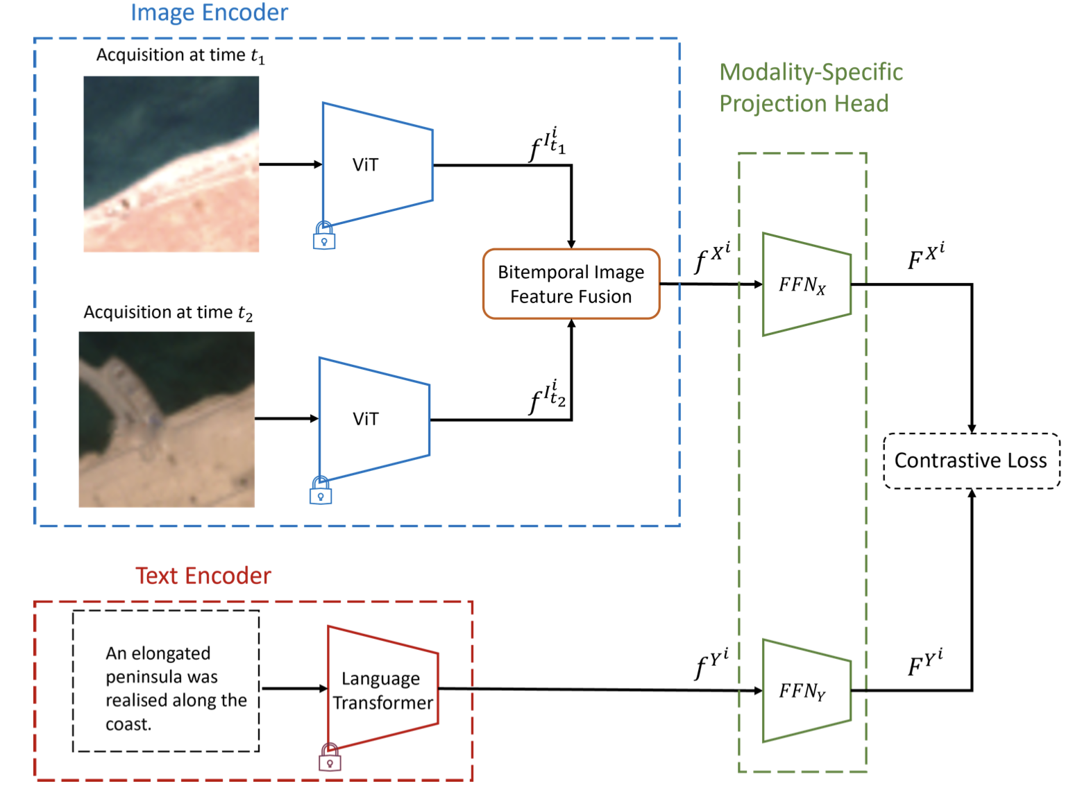
GAIA: A Global, Multimodal, Multiscale Vision-Language Dataset for Remote Sensing Image Analysis
Angelos Zavras, Dimitrios Michail, Xiao Xiang Zhu, Begüm Demir, Ioannis Papoutsis
IEEE Geoscience and Remote Sensing Magazine, 2026.
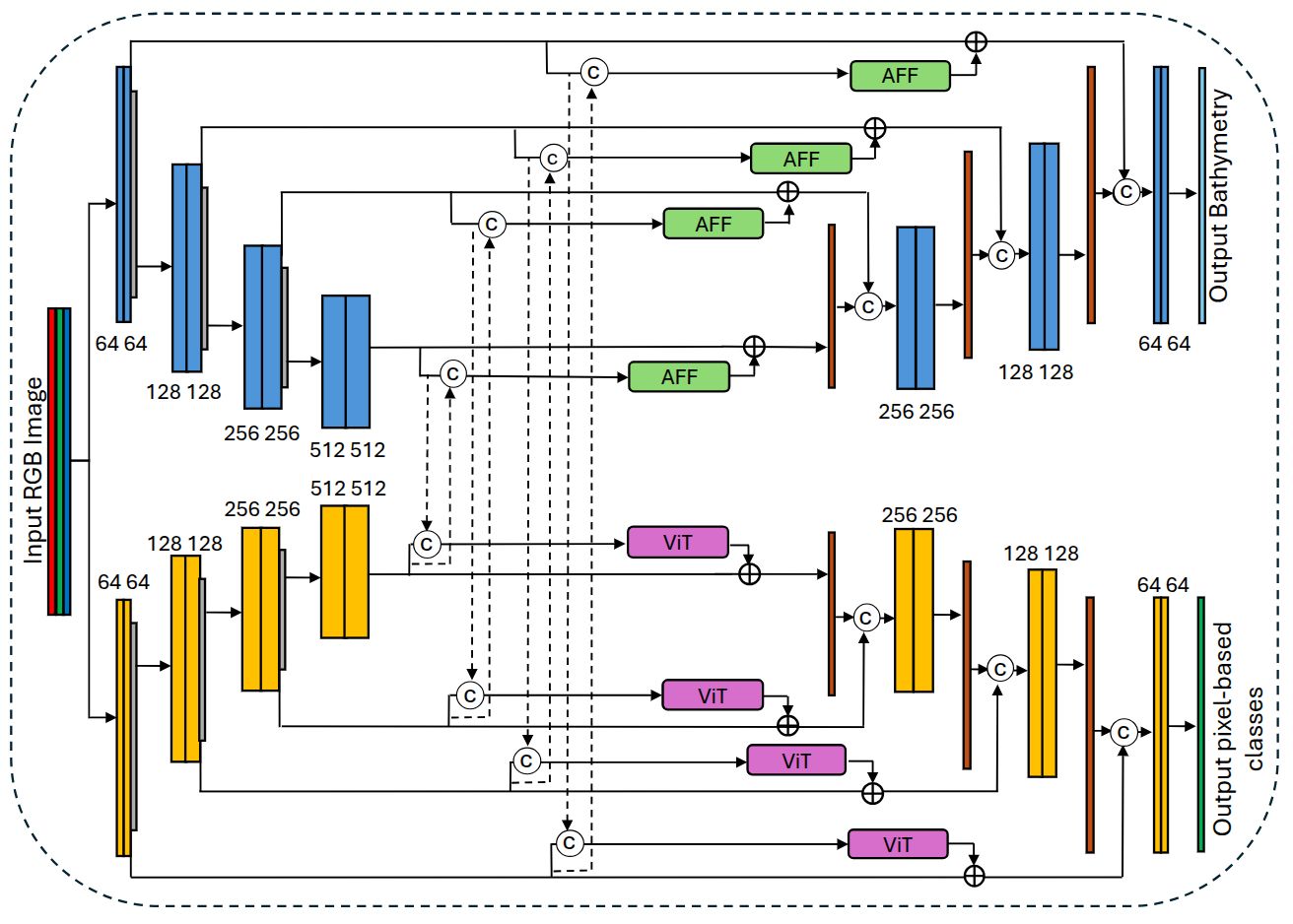
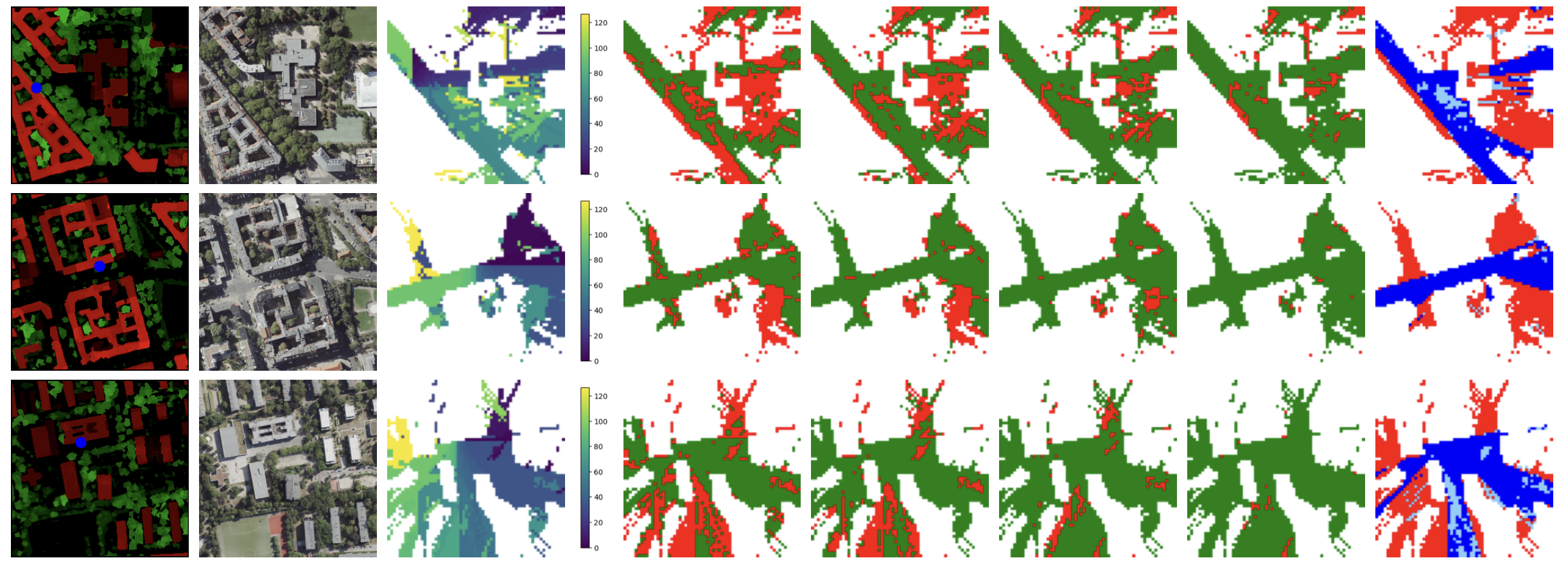
Seabed-Net: A Multi-Task Network for Joint Bathymetry Estimation and Seabed Classification from Remote Sensing Imagery in Shallow Waters
Panagiotis Agrafiotis, Begüm Demir
ISPRS Journal of Photogrammetry and Remote Sensing, 2026.

Hybrid Deep Learning Models for Remote Sensing Image Processing
Matthieu Muller, Daniele Picone, Begüm Demir, Gustau Camps-Valls, Mauro Dalla Mura, Magnus Örn Ulfarsson, Jon Atli Benediktsson
Proceedings of the IEEE, 2026.
International Conferences
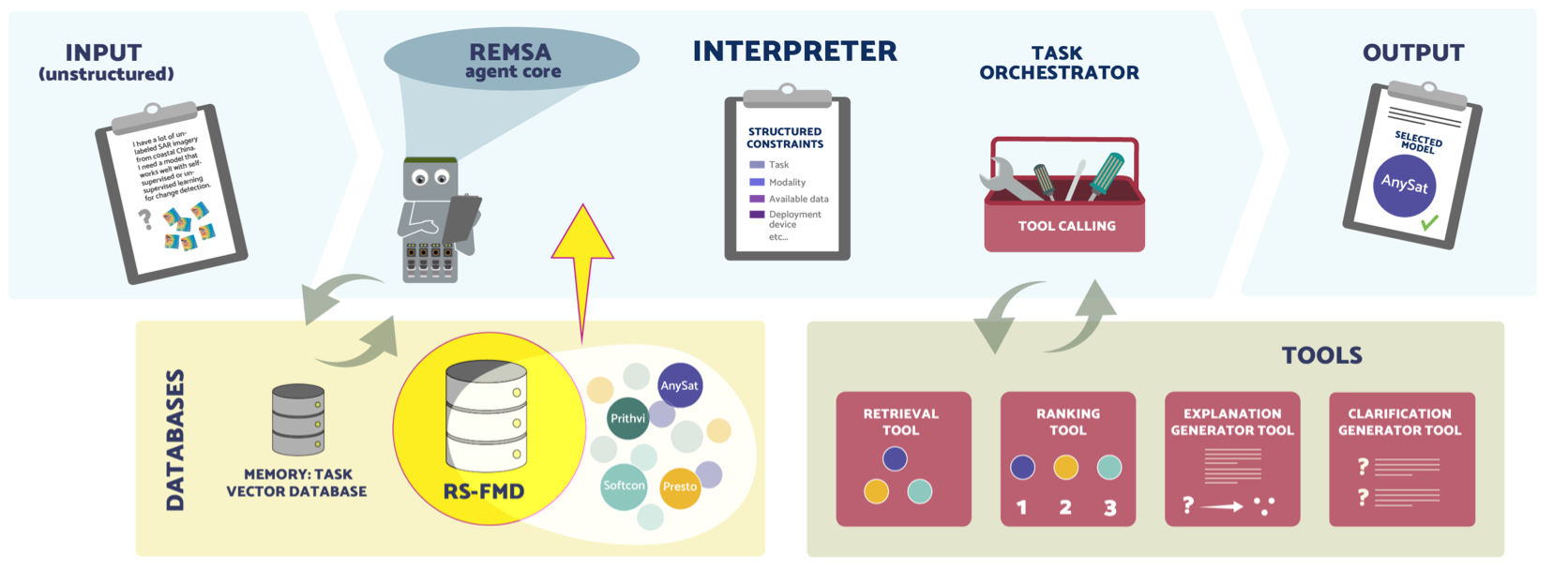
Foundation Model Selection for Remote Sensing via a Constraint-Aware Agent
Binger Chen, Tacettin Emre Bök, Behnood Rasti, Volker Markl, Begüm Demir
European Conference on Computer Vision (ECCV), Malmö, Sweden, 2026.
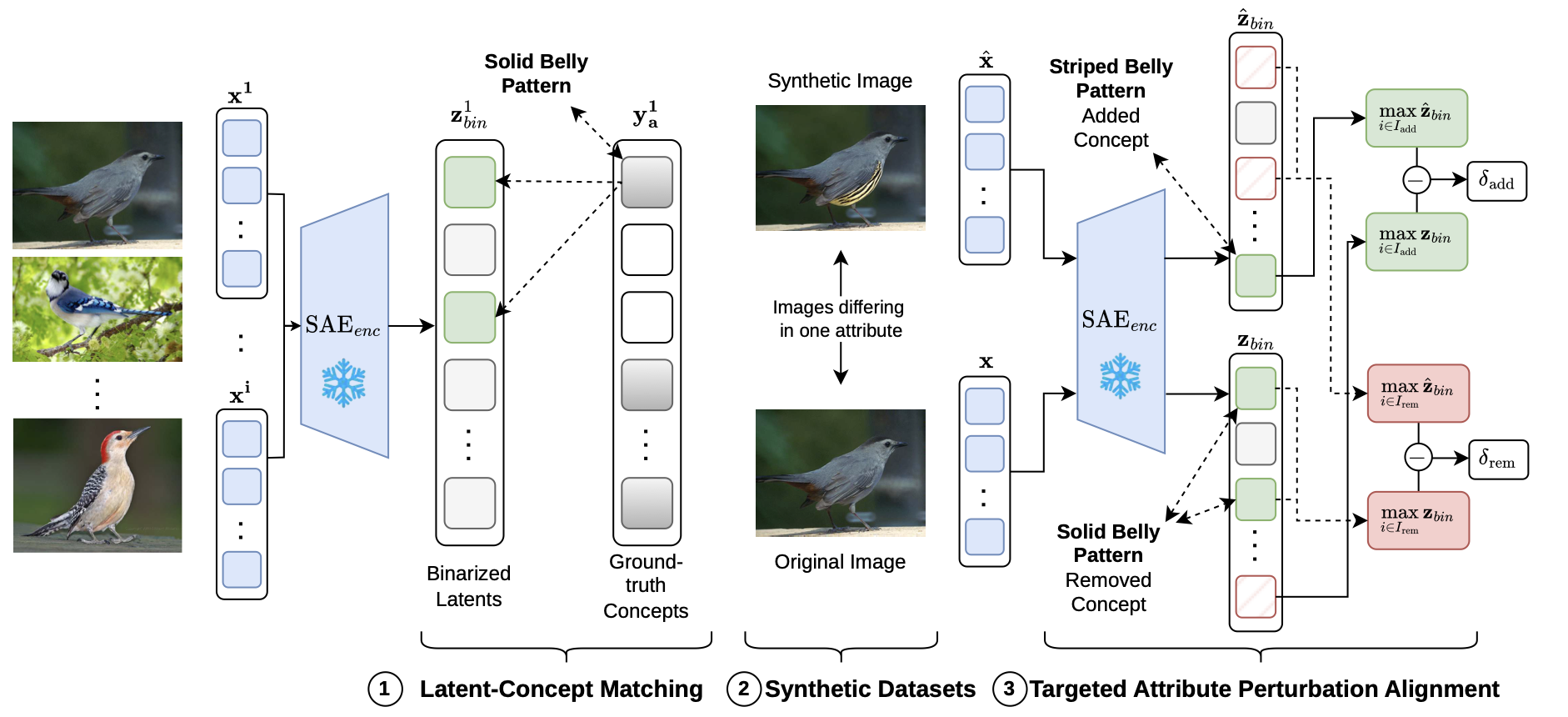
Evaluating the Interpretability of Sparse Autoencoders with Concept Annotations
Jonas Klotz, Cassio F. Dantas, Pallavi Jain, Diego Marcos, Begüm Demir
European Conference on Computer Vision (ECCV), Malmö, Sweden, 2026.
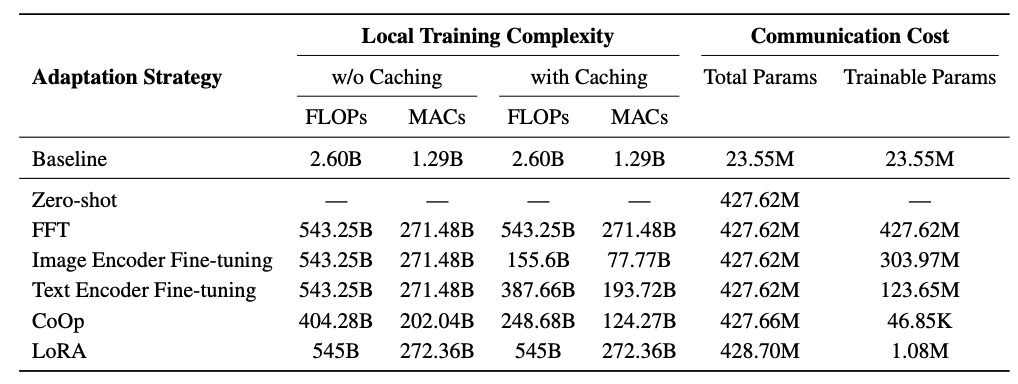
On the Effectiveness of Adaptation Strategies for VLM-Based Federated Learning in Remote Sensing
Simon Lösche, Barış Büyüktaş, Mathis Adler, Angelos Zavras, Ioannis Papoutsis, Begüm Demir
SPIE Artificial Intelligence and Image and Signal Processing for Remote Sensing, Edinburg, Scotland, 2026.
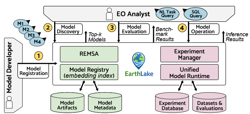
Demonstrating EarthLake: A Model Lake System for Earth Observation Foundation Model Management
Binger Chen, Haralampos Gavriilidis, Luca Gaedicke, Tacettin Emre Bök, Matthias Boehm, Ziawasch Abedjan, Begüm Demir, Volker Markl
International Conference on Very Large Databases, Boston, USA, Sept. 2026.
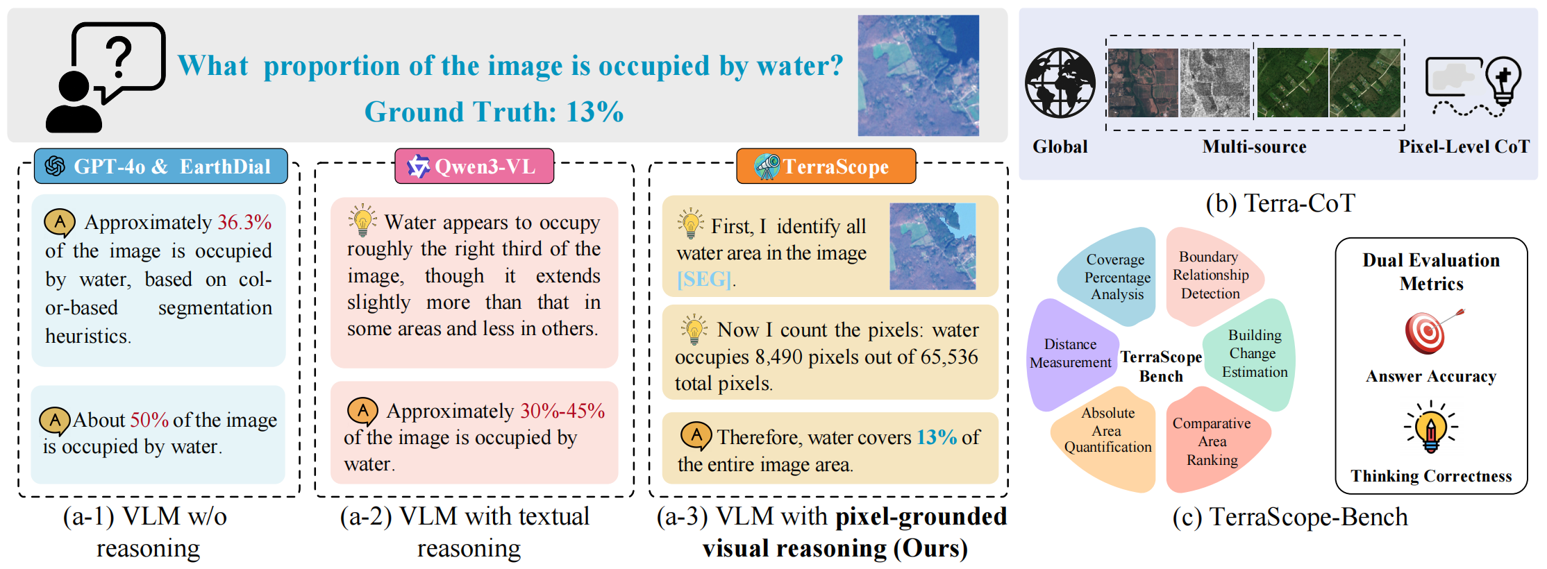
TerraScope: Pixel-Grounded Visual Reasoning for Earth Observation
Yan Shu, Bin Ren, Zhitong Xiong, Xiaoxiang Zhu, Begüm Demir, Nicu Sebe and Paolo Rota
Proceedings of the IEEE/CVF Conference on Computer Vision and Pattern Recognition (CVPR), 2026.

Rank-based Geographical Regularization: Revisiting Contrastive Self-Supervised Learning for Multispectral Remote Sensing Imagery
Tom Burgert, Leonard Hackel, Paolo Rota, Begüm Demir
Proceedings of the IEEE/CVF Winter Conference on Applications of Computer Vision, Accepted as an Oral, 2026.
2025
International Journals

Earth Action in Transition: Highlights From the 2025 ESA–NASA International Workshop on AI Foundation Models for EO
N. Longépé et al.
IEEE Geoscience and Remote Sensing Magazine, vol. 13, no. 4, pp. 457-462, Dec. 2025, doi: 10.1109/MGRS.2025.3592035.
A Label Propagation Strategy for CutMix in Multi-Label Remote Sensing Image Classification
Tom Burgert, Kai Norman Clasen, Jonas Klotz, Tim Siebert, Begüm Demir
IEEE Journal of Selected Topics in Applied Earth Observations and Remote Sensing, 2025.
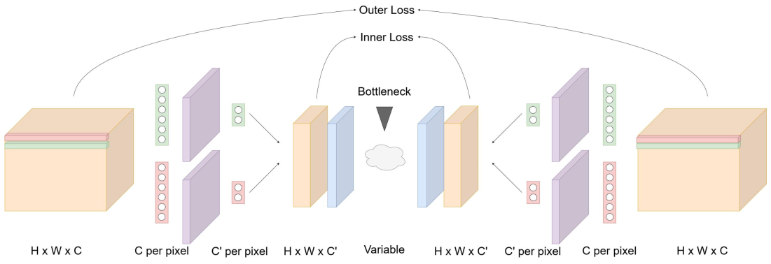
Adjustable Spatio-Spectral Hyperspectral Image Compression Network
Martin Hermann Paul Fuchs, Behnood Rasti, Begüm Demir
IEEE Journal of Selected Topics in Applied Earth Observations and Remote Sensing, 2025.
On the Effectiveness of Methods and Metrics for Explainable AI in Remote Sensing Image Scene Classification
Jonas Klotz, Tom Burgert, Begüm Demir
IEEE Journal of Selected Topics in Applied Earth Observations and Remote Sensing, 2025.
A Multi-Modal Federated Learning Framework for Remote Sensing Image Classification
Barış Büyüktaş, Gencer Sumbul, Begüm Demir
IEEE Transactions on Geoscience and Remote Sensing, 2025.
Sea-Undistort: A Dataset for Through-Water Image Restoration in High Resolution Airborne Bathymetric Mapping
Maximilian Kromer, Panagiotis Agrafiotis, Begüm Demir
IEEE Geoscience and Remote Sensing Letters, 2025.
Self-Supervised Cross-Modal Text-Image Time Series Retrieval in Remote Sensing
Genc Hoxha, Olivér Angyal, Begüm Demir
IEEE Transactions on Geoscience and Remote Sensing, 2025.
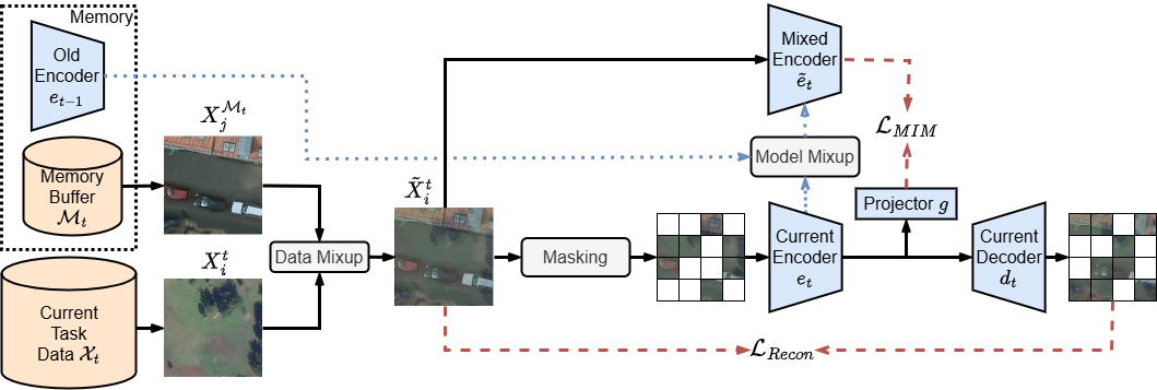
Continual Self-Supervised Learning with Masked Autoencoders in Remote Sensing
Lars Möllenbrok, Behnood Rasti, Begüm Demir
IEEE Geoscience and Remote Sensing Letters, 2025.
Mind the Modality Gap: Towards a Remote Sensing Vision-Language Model via Cross-modal Alignment
Angelos Zavras, Dimitrios Michail, Begüm Demir, Ioannis Papoutsis
ISPRS Journal of Photogrammetry and Remote Sensing, 2025.
Radio Map Prediction from Aerial Images and Application to Coverage Optimization
Fabian Jaensch, Giuseppe Caire, Begüm Demir
IEEE Transactions on Wireless Communications, 2025.
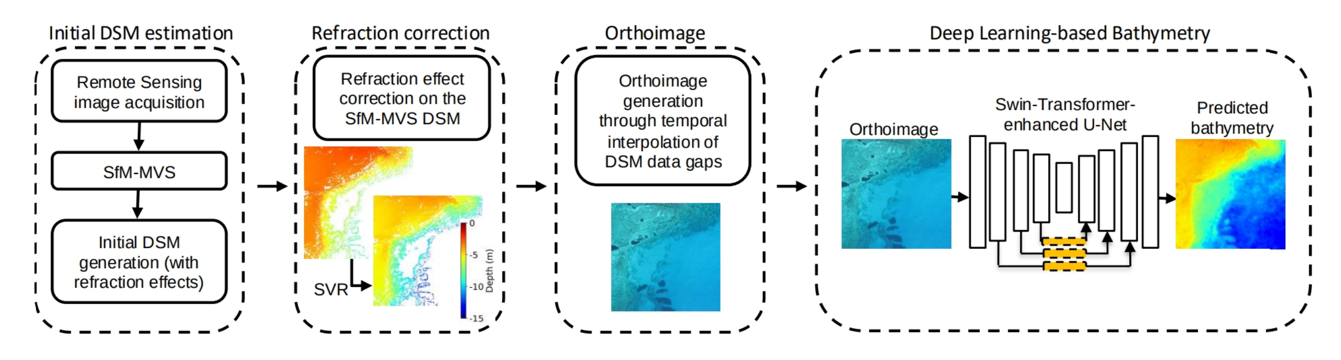
Deep Learning-based Bathymetry Retrieval without In-Situ Depths using Remote Sensing Imagery and SfM-MVS DSMs with Data Gaps
Panagiotis Agrafiotis, Begüm Demir
ISPRS Journal of Photogrammetry and Remote Sensing, 2025.
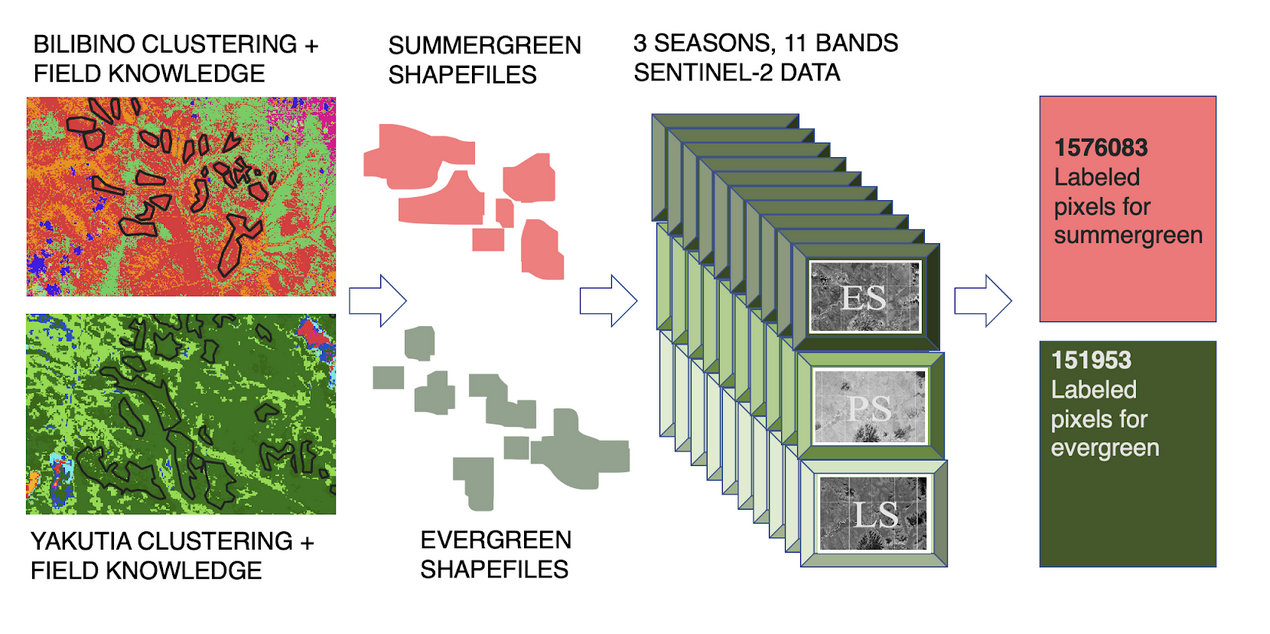
A Benchmark Dataset for Sentinel-2 Based Forest Type Classification in the Siberian Summergreen-Evergreen Forest Transition Zone
Femke van Geffen, Ronny Hänsch, Begüm Demir, Stefan Kruse, Ulrike Herzschuh, and Birgit Heim
IEEE Journal of Selected Topics in Applied Earth Observations and Remote Sensing, 2025.
International Conferences
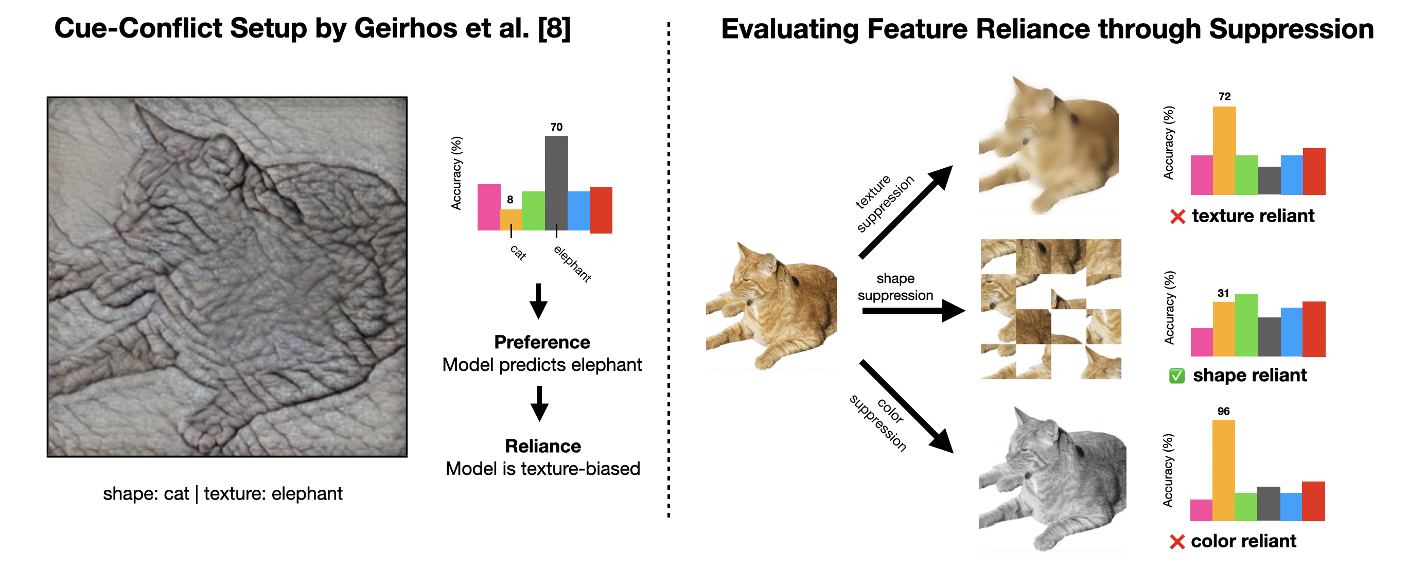
ImageNet-trained CNNs Are Not Biased Towards Texture: Revisiting Feature Reliance Through Controlled Suppression
Tom Burgert, Oliver Stoll, Paolo Rota, Begüm Demir
Advances in Neural Information Processing Systems (NeurIPS), Accepted as an Oral, 2025.
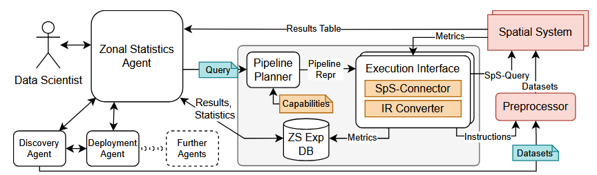
Automating Earth Observation Analytics Pipelines with Agent Raven
Gereon Dusella, Haralampos Gavriilidis, Binger Chen, Begüm Demir, Volker Markl and Eleni Tzirita Zacharatou
Big Data from Space (BiDS) Conference, 2025.
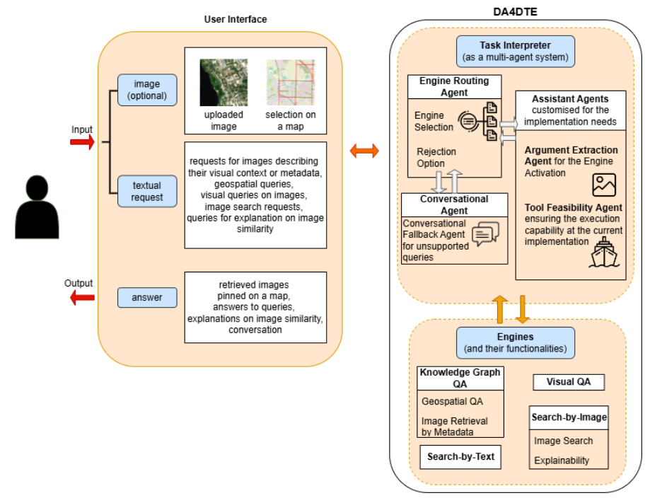
A Multi-Agent System to Orchestrate Interactions with Digital Twins of Earth
Myrto Tsokanaridou, Jakob Hackstein, Genc Hoxha, Sergios-Anestis Kefalidis, Konstantinos Plas, Begüm Demir, Manolis Koubarakis, Marco Corsi, Cristian Leoni, Giorgio Pasquali, Chiara Pratola, Simone Tilia and Nicolas Longépé
Big Data from Space (BiDS) Conference, 2025.
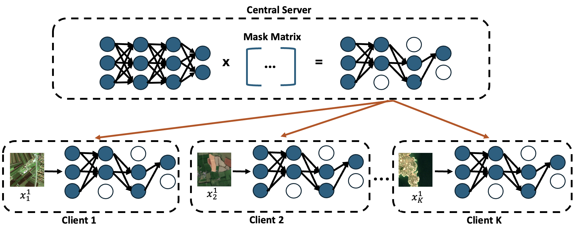
Communication-Efficient Federated Learning Based on Explanation-Guided Pruning for Remote Sensing Image Classification
Jonas Klotz*, Barış Büyüktaş*, Begüm Demir
IEEE International Geoscience and Remote Sensing Symposium, Brisbane, Australia, 2025.
* Equal contribution
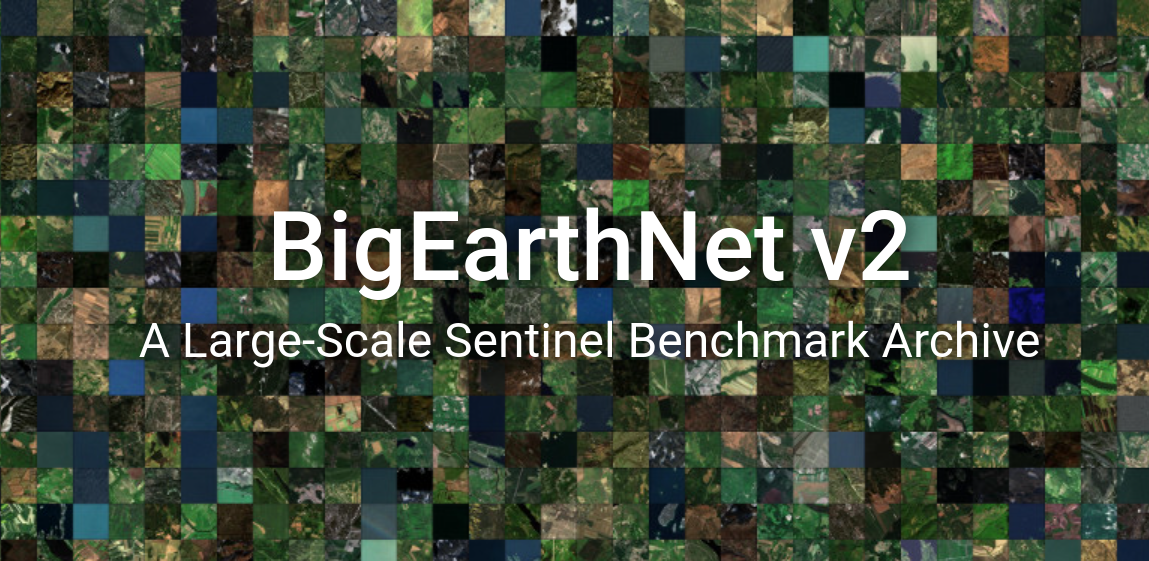
reBEN: Refined BigEarthNet Dataset for Remote Sensing Image Analysis
Kai Norman Clasen*, Leonard Hackel*, Tom Burgert, Gencer Sumbul, Begüm Demir, Volker Markl
IEEE International Geoscience and Remote Sensing Symposium, Brisbane, Australia, 2025.
* Equal contribution
Redundancy-aware Pretraining of Vision-Language Foundation Models in Remote Sensing
Mathis Jürgen Adler*, Leonard Hackel*, Gencer Sumbul, Begüm Demir
IEEE International Geoscience and Remote Sensing Symposium, Brisbane, Australia, 2025.
* Equal contribution
2024
International Journals
Exploring Masked Autoencoders for Sensor-Agnostic Image Retrieval in Remote Sensing
Jakob Hackstein, Gencer Sumbul, Kai Norman Clasen, Begüm Demir
IEEE Transactions on Geoscience and Remote Sensing, doi: 10.1109/TGRS.2024.3517150, 2024.

Artificial Intelligence to Advance Earth Observation: A Review of Models, Recent Trends, and Pathways Forward
Devis Tuia, Konrad Schindler, Begüm Demir, Xiao Xiang Zhu, Mrinalini Kochupillai, Sašo Džeroski, Jan N. van Rijn, Holger H. Hoos, Fabio Del Frate, Mihai Datcu, Volker Markl, Bertrand Le Saux, Rochelle Schneider, Gustau Camps-Valls
IEEE Geoscience and Remote Sensing Magazine, doi: 10.1109/MGRS.2024.3425961, 2024.
Annotation Cost-Efficient Active Learning for Deep Metric Learning Driven Remote Sensing Image Retrieval
Genc Hoxha, Gencer Sumbul, Julia Henkel, Lars Möllenbrok, Begüm Demir
IEEE Transactions on Geoscience and Remote Sensing, doi: 10.1109/TGRS.2024.3438430, 2024.
Federated Learning Across Decentralized and Unshared Archives for Remote Sensing Image Classification
Barış Büyüktaş, Gencer Sumbul, Begüm Demir
IEEE Geoscience and Remote Sensing Magazine, doi: 10.1109/MGRS.2024.3415391, 2024.
ConfigILM: A General Purpose Configurable Library for Combining Image and Language Models for Visual Question Answering
Leonard Hackel, Kai Norman Clasen, Begüm Demir
SoftwareX, p.101731, doi: 10.1016/j.softx.2024.101731, 2024.
A Novel Semantic Content-based Retrieval System for Hyperspectral Remote Sensing Imagery
Fatih Ömrüuzun, Yasemin Yardımcı Çetin, Uğur Murat Leloğlu, Begüm Demir
MDPI Remote Sensing, 2024.
Unraveling Boreal Forest Composition and Drivers Across Scales in Eastern Siberia
Léa Chloé Marie Enguehard, Stefan Kruse, Birgit Heim, Ingmar Nitze, Nicola Falco, Begüm Demir, Ulrike Herzschuh
Environmental Research Letters, doi: 10.1088/1748-9326/ad5742, 2024.
High Resolution Optical and Acoustic Remote Sensing Datasets of the Puck Lagoon
Łukasz Janowski, Dimitrios Skarlatos, Panagiotis Agrafiotis, Paweł Tysiąc, Andrzej Pydyn, Mateusz Popek, Anna M. Kotarba-Morley, Gottfried Mandlburger, Łukasz Gajewski, Mateusz Kołakowski, Alexandra Papadaki, Juliusz Gajewski
Scientific Data, doi: 10.1038/s41597-024-03199-y, 2024.
International Conferences

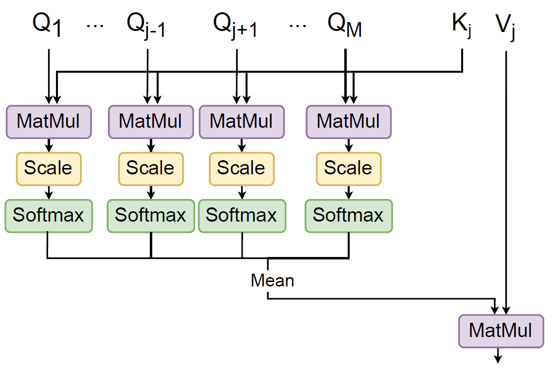
HyCoT: A Transformer-Based Autoencoder for Hyperspectral Image Compression
Martin Hermann Paul Fuchs, Behnood Rasti, Begüm Demir
IEEE GRSS Workshop on Hyperspectral Image and Signal Processing: Evolution in Remote Sensing (WHISPERS), Helsinki, Finland, 2024.
Generative Adversarial Networks for Spatio-Spectral Compression of Hyperspectral Images
Martin Hermann Paul Fuchs, Akshara Preethy Byju, Alisa Walda, Behnood Rasti, Begüm Demir
IEEE GRSS Workshop on Hyperspectral Image and Signal Processing: Evolution in Remote Sensing (WHISPERS), Helsinki, Finland, 2024.
Optimized Martian Dust Displacement Detection Using Explainable Machine Learning
Ana Lomashvili, Elise Clave, Kristin Rammelkamp, Christoph H. Egerland, Olivier Gasnault, Susanne Schroder, Protim Bhattacharjee, Begüm Demir, Nina L. Lanza
3rd Workshop on AI for Space, CVPR 2024, Seattle, WA, USA, 2024.
Learning-Based Hyperspectral Image Compression Using A Spatio-Spectral Approach
Niklas Sprengel, Martin Hermann Paul Fuchs, Begüm Demir
EGU General Assembly, Vienna, Austria, 2024.
Multi-Modal Vision Transformers for Crop Mapping from Satellite Image Time Series
Theresa Follath, David Mickisch, Jan Hemmerling, Stefan Erasmi, Marcel Schwieder, Begüm Demir
IEEE International Geoscience and Remote Sensing Symposium, Athens, Greece, 2024.
Transformer-based Federated Learning for Multi-Label Remote Sensing Image Classification
Barış Büyüktaş, Kenneth Weitzel, Sebastian Völkers, Felix Zailskas, Begüm Demir
IEEE International Geoscience and Remote Sensing Symposium, Athens, Greece, 2024.
Estimating Physical Information Consistency of Channel Data Augmentation for Remote Sensing Images
Tom Burgert, Begüm Demir
IEEE International Geoscience and Remote Sensing Symposium, Athens, Greece, 2024.
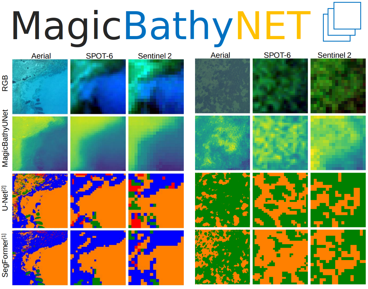
MagicBathyNet: A Multimodal Remote Sensing Dataset for Bathymetry Prediction and Pixel-based Classification in Shallow Waters
Panagiotis Agrafiotis , Łukasz Janowski , Dimitrios Skarlatos, Begüm Demir
IEEE International Geoscience and Remote Sensing Symposium, Athens, Greece, 2024.
A Digital Assistant for Digital Twin Earth
Manolis Koubarakis, Marco Corsi, Cristian Leoni, Giorgio Pasquali, Chiara Pratola, Simone Tilia, Sergios-Anestis Kefalidis, Konstantinos Plas, Mariangela Pollali, Myrto Tsokanaridou, Jakob Heinrich Hackstein, Gencer Sümbül, and Begüm Demir
EGU General Assembly, Vienna, Austria, 2024.
2023
International Journals
Deep Active Learning for Multi-Label Classification of Remote Sensing Images
Lars Möllenbrok, Gencer Sumbul, Begüm Demir
IEEE Geoscience and Remote Sensing Letters, doi: 10.1109/LGRS.2023.3305647, 2023.
Generative Reasoning Integrated Label Noise Robust Deep Image Representation Learning
Gencer Sumbul, Begüm Demir
IEEE Transactions on Image Processing, vol. 32, pp. 4529-4542, 2023, doi: 10.1109/TIP.2023.3293776, 2023.
TreeSatAI Benchmark Archive: a Multi-Sensor, Multi-Label Dataset for Tree Species Classification in Remote Sensing
Steve Ahlswede, Christian Schulz, Christiano Gava, Patrick Helber, Benjamin Bischke, Michael Förster, Florencia Arias, Jörn Hees, Begüm Demir, and Birgit Kleinschmit
Earth System Science Data, vol. 15, no. 2, pp. 681–695, 2023.
International Conferences
LIT-4-RSVQA: Lightweight Transformer-based Visual Question Answering in Remote Sensing
Leonard Hackel*, Kai Norman Clasen*, Mahdyar Ravanbakhsh, Begüm Demir
IEEE International Geoscience and Remote Sensing Symposium, Pasadena, California, 2023.
* Equal contribution
Label Noise Robust Image Representation Learning based on Supervised Variational Autoencoders in Remote Sensing
Gencer Sumbul, Begüm Demir
IEEE International Geoscience and Remote Sensing Symposium, Pasadena, California, 2023.
Transformer-based Multi-Modal Learning for Multi-Label Remote Sensing Image Classification
David Sebastian Hoffmann*, Kai Norman Clasen*, Begüm Demir
IEEE International Geoscience and Remote Sensing Symposium, Pasadena, California, 2023.
* Equal contribution
Learning Across Decentralized Multi-Modal Remote Sensing Archives with Federated Learning
Barış Büyüktaş, Gencer Sumbul, Begüm Demir
IEEE International Geoscience and Remote Sensing Symposium, Pasadena, California, 2023.
HySpecNet-11k: A Large-Scale Hyperspectral Dataset for Benchmarking Learning-Based Hyperspectral Image Compression Methods
Martin Hermann Paul Fuchs, Begüm Demir
IEEE International Geoscience and Remote Sensing Symposium, Pasadena, California, 2023.
Active Learning Guided Fine-Tuning for Enhancing Self-Supervised Based Multi-Label Classification of Remote Sensing Images
Lars Möllenbrok, Begüm Demir
IEEE International Geoscience and Remote Sensing Symposium, Pasadena, California, 2023.
Annotation Cost Efficient Active Learning for Remote Sensing Image Retrieval
Julia Henkel, Genc Hoxha, Gencer Sumbul, Lars Möllenbrok, Begüm Demir
IEEE International Geoscience and Remote Sensing Symposium, Pasadena, California, 2023.
BEN-GE: Extending BigEarthNet with Geographical and Environmental Data
Michael Mommert, Nicolas Kesseli, Joelle Hanna, Linus Scheibenreif, Damian Borth, Begüm Demir
IEEE International Geoscience and Remote Sensing Symposium, Pasadena, California, 2023.

Wayang AgoraEO Plugin: The Framework for Scalable EO Workflows
Rodrigo Pardo Meza, Jorge-Arnulfo Quiané-Ruiz, Begüm Demir, and Volker Markl
EGU General Assembly, Vienna, Austria, 2023.
Construction of Interactive Websites for Remote Sensing Datasets
Kai Norman Clasen and Begüm Demir
EGU General Assembly, Vienna, Austria, 2023.
Book Chapters
Analyzing and Improving the Quality and Fitness for Purpose of OpenStreetMap as Labels in Remote Sensing Applications
Moritz Schott, Adina Zell, Sven Lautenbach, Gencer Sumbul, Michael Schultz, Alexander Zipf, Begüm Demir
Volunteered Geographic Information: Interpretation, Visualization and Social Context, Springer, ISBN: 978-3031353765, 2023.
2022
International Journals
On the Effects of Different Types of Label Noise in Multi-Label Remote Sensing Image Classification
Tom Burgert, Mahdyar Ravanbakhsh, Begüm Demir
IEEE Transactions on Geoscience and Remote Sensing, vol. 60, doi: 10.1109/TGRS.2022.3226371, 2022.
Towards Simultaneous Image Compression and Indexing for Scalable Content-Based Retrieval in Remote Sensing
Gencer Sumbul, Jun Xiang, Begüm Demir
IEEE Transactions on Geoscience and Remote Sensing, vol. 60, 10.1109/TGRS.2022.3204914, 2022.
Plasticity-Stability Preserving Multi-Task Learning for Remote Sensing Image Retrieval
Gencer Sumbul, Begüm Demir
IEEE Transactions on Geoscience and Remote Sensing, vol. 60, doi: 10.1109/TGRS.2022.3160097, 2022.
Multi-Label Noise Robust Collaborative Learning for Remote Sensing Image Classification
Ahmet Kerem Aksoy, Mahdyar Ravanbakhsh, Begüm Demir
IEEE Transactions on Neural Networks and Learning Systems, doi:10.1109/TNNLS.2022.3209992, 2022.
Informative and Representative Triplet Selection for Multi-Label Remote Sensing Image Retrieval
Gencer Sumbul, Mahdyar Ravanbakhsh, Begüm Demir
IEEE Transactions on Geoscience and Remote Sensing, vol. 60, doi: 10.1109/TGRS.2021.3124326, 2022.

ESA-ECMWF Report on Recent Progress and Research Directions in Machine Learning for Earth System Observation and Prediction
Rochelle Schneider, Massimo Bonavita, Alan Geer, Rossella Arcucci, Peter Dueben, Claudia Vitolo, Bertrand Le Saux, Begüm Demir, and Pierre-Philippe Mathieu
npj Climate and Atmospheric Science, vol. 5, no. 51, 2022.
International Conferences
Advanced Deep Learning Architectures for Accurate Detection of Subsurface Tile Drainage Pipes from Remote Sensing Images
Tom-Lukas Breitkopf*, Leonard Hackel*, Mahdyar Ravanbakhsh, Anne-Karin Cooke, Sandra Willkommen, Stefan Broda, Begüm Demir
SPIE Image and Signal Processing for Remote Sensing, Berlin, 2022.
* Equal contribution
Multi-Modal Fusion Transformer for Visual Question Answering in Remote Sensing
Tim Siebert*, Kai Norman Clasen*, Mahdyar Ravanbakhsh, Begüm Demir
SPIE Image and Signal Processing for Remote Sensing, Berlin, 2022.
* Equal contribution
Satellite Image Search in AgoraEO
Ahmet Kerem Aksoy, Pavel Dushev, Eleni Tzirita Zacharatou, Holmer Hemsen, Marcela Charfuelan, Jorge-Arnulfo Quiané-Ruiz, Begüm Demir, Volker Markl
International Conference on Very Large Databases, Sydney, Australia, Sept. 2022.
A Novel Framework to Jointly Compress and Index Remote Sensing Images for Efficient Content-based Retrieval
Gencer Sumbul*, Jun Xiang*, Nimisha Madam and Begüm Demіr
IEEE International Geoscience and Remote Sensing Symposium, Kuala Lumpur, Malaysia, 2022.
* Equal contribution
Weakly Supervised Semantic Segmentation of Remote Sensing Images for Tree Species Classification Based on Explanation Methods
Steve Ahlswede, Nimisha Madam, Christian Schulz, Birgit Kleinschmit and Begüm Demіr
IEEE International Geoscience and Remote Sensing Symposium, Kuala Lumpur, Malaysia, 2022.
A Novel Self-Supervised Cross-Modal Image Retrieval Method in Remote Sensing
Gencer Sumbul, Markus Müller, Begüm Demіr
IEEE International Conference on Image Processing (ICIP), Bordeaux, France, 2022.
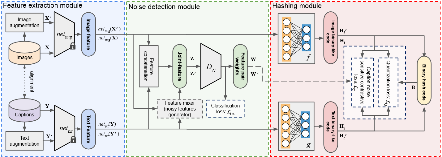
An Unsupervised Cross-Modal Hashing Method Robust to Noisy Training Image-Text Correspondences in Remote Sensing
Georgii Mikriukov, Mahdyar Ravanbakhsh, Begüm Demir
IEEE International Conference on Image Processing (ICIP), Bordeaux, France, 2022.
Deep Metric Learning-Based Semi-Supervised Regression With Alternate Learning
Adina Zell, Gencer Sumbul and Begüm Demіr
IEEE International Conference on Image Processing (ICIP), Bordeaux, France, 2022.
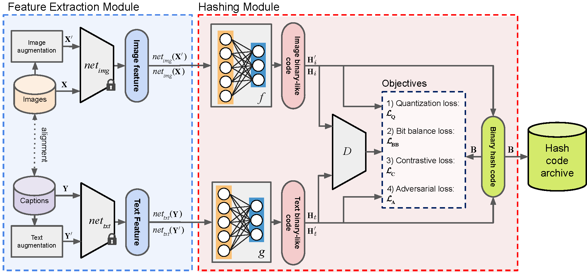
Unsupervised Contrastive Hashing for Cross-Modal Retrieval in Remote Sensing
Georgii Mikriukov, Mahdyar Ravanbakhsh, Begüm Demir
IEEE International Conference on Acoustics, Speech, & Signal Processing (ICASSP), Singapore, 2022.
Deep Learning Driven Content-Based Image Time-Series Retrieval in Remote Sensing Archives
Onat Vuran, Oguzhan Akcin, Mahdyar Ravanbakhsh, Bülent Sankur, Begüm Demir
IEEE International Geoscience and Remote Sensing Symposium, Kuala Lumpur, Malaysia, 2022.

Leveraging quality insights of OpenStreetMap-based land-use/land-cover multi-label modeling to the community
Moritz Schott, Adina Zell, Sven Lautenbach, Begüm Demir and Alexander Zipf
The State of the Map Conference, 2022.
2021
International Journals
BigEarthNet-MM: A Large Scale Multi-Modal Multi-Label Benchmark Archive for Remote Sensing Image Classification and Retrieval
Gencer Sumbul, Arne de Wall, Tristan Kreuziger, Filipe Marcelino, Hugo Costa, Pedro Benevides, Mário Caetano, Begüm Demir, Volker Markl
IEEE Geoscience and Remote Sensing Magazine, vol. 9, no. 3, pp. 174-180, Sept. 2021.
Metric-Learning based Deep Hashing Network for Content Based Retrieval of Remote Sensing Images
Subhankar Roy, Enver Sangineto, Begüm Demir and Nicu Sebe
IEEE Geoscience and Remote Sensing Letters, vol. 18, no. 2, pp. 226-230, 2021.
Unsupervised Remote Sensing Image Retrieval using Probabilistic Latent Semantic Hashing
Ruben Fernandez-Beltrán, Begüm Demir, Filiberto Pla and Antonio Plaza
IEEE Geoscience and Remote Sensing Letters, vol. 18, no. 2, pp. 256-260, 2021.
Learning Convolutional Sparse Coding on Complex Domain for Interferometric Phase Restoration
Jian Kang, Danfeng Hong, Jialin Liu, Gearld Baier, Naoto Yokoya and Begüm Demir
IEEE Transactions on Neural Networks and Learning Systems, vol. 32, no. 2, pp. 826-840, 2021.
SD-RSIC: Summarization Driven Deep Remote Sensing Image Captioning
Gencer Sumbul, Sonali Nayak, Begüm Demir
IEEE Transactions on Geoscience and Remote Sensing, vol. 59, no. 8, pp. 6922-6934, 2021.
Remote Sensing Image Scene Classification with Deep Neural Networks in JPEG 2000 Compressed Domain
Akshara Preethy Byju, Gencer Sumbul, Begüm Demir and Lorenzo Bruzzone
IEEE Transactions on Geoscience and Remote Sensing, vol. 59, no. 4, pp. 3458-3472, 2021.
International Conferences
SiDroForest Siberian Drone-mapped Forest inventory
Femke van Geffen, Birgit Heim, Ulrike Herzschuh, Luidmila Pestryakova, Evgenii Zakharov, Ronny Hänsch, Begüm Demir, Birgit Kleinschmit, Michael Förster, and Stefan Kruse
EGU General Assembly, 2021.
A Consensual Collaborative Learning Method for Remote Sensing Image Classification Under Noisy Multi-Labels
Ahmet Kerem Aksoy, Mahdyar Ravanbakhsh, Tristan Kreuziger, Begüm Demir
IEEE International Conference on Image Processing, Anchorage, Alaska, USA, 2021.
RSVQA Meets BigEarthNet: A New, Large-Scale, Visual Question Answering Dataset for Remote Sensing
Sylvain Lobry, Begüm Demir, Devis Tuia
IEEE International Geoscience and Remote Sensing Symposium, Brussels, Belgium, 2021.
Agora-EO: A Unified Ecosystem for Earth Observation - A Vision for Boosting EO Data Literacy
Arne de Wall, Björn Deiseroth, Eleni Tzirita Zacharatou, Jorge-Arnulfo Quiané-Ruiz, Begüm Demir and Volker Markl
Big Data from Space Conference, 2021.
A Novel Graph-Theoretic Deep Representation Learning Method for Multi-Label Remote Sensing Image Retrieval
Gencer Sumbul, Begüm Demir
IEEE International Geoscience and Remote Sensing Symposium, Brussels, Belgium, 2021.
Book Chapters
Deep Learning for Image Search and Retrieval in Large Remote Sensing Archives
Gencer Sumbul, Jian Kang, Begüm Demir
Deep learning for the Earth Sciences: A Comprehensive Approach to Remote Sensing, Climate Science and Geosciences, John Wiley & Sons, ISBN: 978-1-119-64614-3, 2021.
2020
International Journals
Toward Remote Sensing Image Retrieval Under a Deep Image Captioning Perspective
Genc Hoxha, Farid Melgani, Begüm Demir
IEEE Journal of Selected Topics in Applied Earth Observations and Remote Sensing, vol.13, pp. 4462-4475, 2020.
A Progressive Content Based Image Retrieval in JPEG 2000 Compressed Remote Sensing Archives
Akshara Preethy Byju, Begüm Demir and Lorenzo Bruzzone
IEEE Transactions on Geoscience and Remote Sensing, vol. 58, no. 8, pp. 5739-5751, 2020.
A Deep Multi-Attention Driven Approach for Multi-Label Remote Sensing Image Classification
Gencer Sumbul, Begüm Demir
IEEE Access, vol. 8, pp. 95934-95946, 2020.
International Conferences
Band-Wise Multi-Scale CNN Architecture for Remote Sensing Image Scene Classification
Jian Kang, Begüm Demir
IEEE International Geoscience and Remote Sensing Symposium, Waikoloa, HI, USA, pp. 1687-1690, 2020.
S2-cGAN: Self-Supervised Adversarial Representation Learning for Binary Change Detection in Multispectral Images
Jose Luis Holgado Alvarez, Mahdyar Ravanbakhsh, Begüm Demir
IEEE International Geoscience and Remote Sensing Symposium, Waikoloa, HI, USA, pp. 2515-2518, 2020.
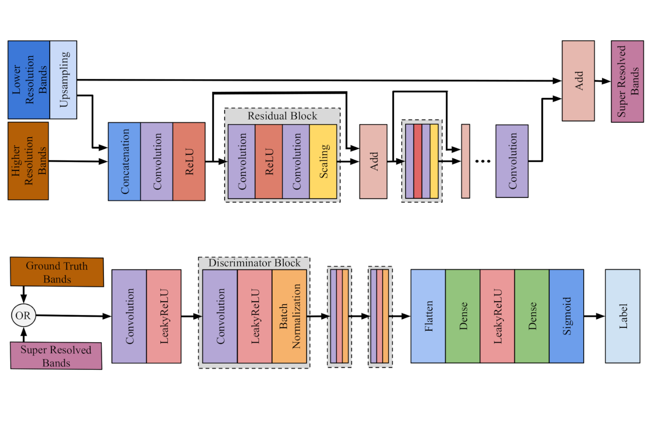
An Approach to Super-Resolution of Sentinel-2 Images Based on Generative Adversarial Networks
Kexin Zhang, Gencer Sumbul, Begüm Demir
Mediterranean and Middle-East Geoscience and Remote Sensing Symposium (M2GARSS), 2020.
A Comparative Study of Deep Learning Loss Functions for Multi-Label Remote Sensing Image Classification
Hichame Yessou, Gencer Sumbul, Begüm Demir
IEEE International Geoscience and Remote Sensing Symposium, Waikoloa, HI, USA, pp. 1349-1352, 2020.
2019
International Journals
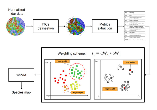
A Weighted SVM-Based Approach to Tree Species Classification at Individual Tree Crown Level Using LiDAR Data
Hoang Minh Nguyen, Begüm Demir, Michele Dalponte
MDPI Remote Sensing, vol. 11, no. 24, pp. 2948, 2019.
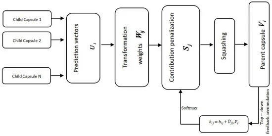
Capsule Networks for Object Detection in UAV Imagery
Mohamed Lamine Mekhalfi, Mesay Belete Bejiga, Davide Soresina, Farid Melgani and Begüm Demir
MDPI Remote Sensing, 11(14):1694, 2019.
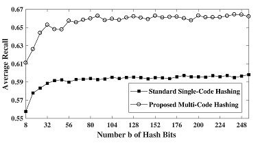
An Unsupervised Multicode Hashing Method for Accurate and Scalable Remote Sensing Image Retrieval
Thomas Reato, Begüm Demir and Lorenzo Bruzzone
IEEE Geoscience and Remote Sensing Letters, 16(2):276-280, 2019.
A Novel Data Fusion Technique for Snow Cover Retrieval
Ludovica De Gregorio, Mattia Callegari, Carlo Marin, Marc Zebisch, Lorenzo Bruzzone, Begüm Demir, Ulrich Strasser, Thomas Marke, Daniel Günther, R. Nadalet and Claudia Notarnicola
IEEE Journal of Selected Topics in Applied Earth Observations and Remote Sensing, 12(8):2862-2877, 2019.
International Conferences
Retrieving Images with Generated Textual Descriptions
Genc Hoxha, Farid Melgani, Begüm Demir
IEEE International Geoscience and Remote Sensing Symposium, pp.5812-5815, 2019.
Approximating JPEG 2000 wavelet representation through deep neural networks for remote sensing image scene classification
Akshara Preethy Byju and Gencer Sumbul and Begüm Demir and Lorenzo Bruzzone
SPIE Image and Signal Processing for Remote Sensing, 111550S, 2019.
Weighted Support Vector Machines for Tree Species Classification using Lidar Data
Hoang Minh Nguyen and Begüm Demir and Michele Dalponte
IEEE International Geoscience and Remote Sensing Symposium, 6740-6743, 2019.
A Novel Multi-Attention Driven System for Multi-Label Remote Sensing Image Classification
Gencer Sümbül and Begüm Demir
IEEE International Geoscience and Remote Sensing Symposium, 5726-5729, 2019.
BigEarthNet: A Large-Scale Benchmark Archive for Remote Sensing Image Understanding
Gencer Sümbül and Marcela Charfuelan and Begüm Demir and Volker Markl
IEEE International Geoscience and Remote Sensing Symposium, 5901-5904, 2019.
2018
International Journals
Multiple Kernel Learning for Remote Sensing Image Classification
Saeid Niazmardi and Begüm Demir and Lorenzo Bruzzone and Abdolreza Safari and Saeid Homayouni
IEEE Trans. Geoscience and Remote Sensing, 1425–1443, 2018.
Multilabel Remote Sensing Image Retrieval Using a Semisupervised Graph-Theoretic Method
Bindita Chaudhuri and Begüm Demir and Subhasis Chaudhuri and Lorenzo Bruzzone
IEEE Trans. Geoscience and Remote Sensing, 1144–1158, 2018.
A Novel System for Content-Based Retrieval of Single and Multi-Label High-Dimensional Remote Sensing Images
Osman Emre Dai and Begüm Demir and Bülent Sankur and Lorenzo Bruzzone
IEEE Journal of Selected Topics in Applied Earth Observations and Remote Sensing, 2473-2490, 2018.
International Conferences
From Big Data to Big Information and Big Knowledge: the Case of Earth Observation Data
Konstantina Bereta, Manolis Koubarakis, Stefan Manegold, George Stamoulis, Begüm Demir
Proceedings of the 27th ACM International Conference on Information and Knowledge Management, 2018.
A Novel Active Learning Technique for Multi-Label Remote Sensing Image Scene Classification
Bayable Teshome Zegeye and Begüm Demir
SPIE Image and Signal Processing for Remote Sensing, 10789 - 10789 - 8, 2018.
Integration of Remote Sensing with A Hydroclimatological Model for an Improved Monitoring of Alpine Glaciers
Mattia Callegari and Carlo Marin and Daniel Günther and Philipp Rastner and Lorenzo Bruzzone and Begüm Demir and Thomas Marke and Ulrich Strasser and Marc Zebisch and Claudia Notarnicola
International Conference on Geoscience and Remote Sensing Symposium, 6239-6242, 2018.
A Novel Data Fusion Technique for Snow Parameter Retrieval
Ludovica Gregorio and Mattia Callegari and Carlo Marin and Marc Zebisch and Lorenzo Bruzzone and Begüm Demir and Ulrich Strasser and Daniel Günther and Thomas Marke and Claudia Notarnicola
International Conference on Geoscience and Remote Sensing Symposium, 6247-6250, 2018.
Advanced Local Binary Patterns for Remote Sensing Image Retrieval
Issayas Tekeste and Begüm Demir
International Conference on Geoscience and Remote Sensing Symposium, 6855-6858, 2018.
Deep Metric and Hash-Code Learning for Content-Based Retrieval of Remote Sensing Images
Subhankar Roy and Enver Sangineto and Begüm Demir and Nicu Sebe
International Geoscience and Remote Sensing Symposium, 4539-4542, 2018.
A Novel Coarse-to-Fine Remote Sensing Image Retrieval System in JPEG-2000 Compressed Domain
Begüm Demir and Akshara Preethy Byju and Lorenzo Bruzzone
SPIE Image and Signal Processing for Remote Sensing, 30, 2018.
Semantic-Fusion Gans for Semi-Supervised Satellite Image Classification
Subhankar Roy and Enver Sangineto and Nicu Sebe and Begüm Demir
International Conference in Image Processing, 684-688, 2018.